
Features Trimble SiteVision
Bring your BIM, GIS and design data to life in outdoor real-world environments with unrivaled accuracy, using theTrimble® SiteVision™ application, combined with a Trimble SiteVision Integrated Positioning System or Trimble Catalyst DA2 Receiver.
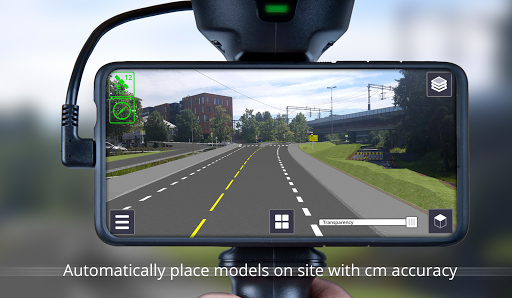
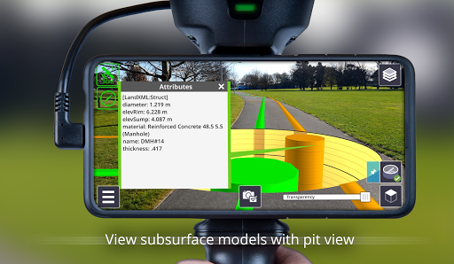
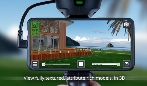
With SiteVision you can easily visualize, collaborate, measure, design, and report using high-accuracy augmented reality.Key features:• Positions AR models outdoors with centimeter accuracy in the real world• View accurately positioned photorealistic 3D models in their real world context• Share your augmented reality view with others to engage with clients and the public• Capture and share accurately georeferenced augmented reality photos• Access rich attribute information from your model• Collaborate with your team through Trimble Connect• Converts 2D GIS data to 3D models using GIS attribute data for GIS AR viewing• Display PDF plans at 1:1 scale on your job site• Measure and record progress and as-built information, including positions, lengths and areas• Remote point measurement for improved safety• Measure between your 3D design model and the real world• Industry workflows supporting every phase, from initial planning, to design, construction and inspection, through to operations and maintenance – Cities, utility companies and government agencies with Esri GIS databases and Web Feature Service connections – Architects, landscape designers, builders and contractors using SketchUp – Building designers and contractors using AutoCAD, Revit, Navisworks and Tekla – Civil designers and contractors using Trimble Business Center, Civil3D, OpenRoads and Novapoint – Utility designers using PLS-CADD and Distribution Design Studio – Transportation planners using Quantm – Utility augmented reality workflows with Trimble Unity and Trimble NIS• Supports open industry data standards - IFC, LandXML, and Open Geospatial Consortium Web Feature Services• Enabled by Trimble RTX and VRS services or internet base stations for global correction service coverage• Create a model in the field, measure data and create scenes to conceptualize design ideas• Create the profile of a trench or embankment and design its location and grade on site.• Design horizontal or sloped planes in the field • Output designs to Trimble EarthworksSupported Devices and Minimum Requirements• Android 9.0 and above• Google® Play Services for AR supported phone• Minimum recommended RAM of 4GBNote: This app is for use with the Trimble SiteVision Integrated Positioning System.
To use the Trimble SiteVision system you need a Trimble SiteVision Subscription.To purchase a Trimble SiteVision Integrated Positioning System contact your local Trimble distributor.
For help or further information about Trimble SiteVision, and to find your nearest stockist, visit https://sitevision.trimble.comEnd User License Agreement:https://sitevision.trimble.com/sitevision-end-user-license-agreement/Trimble Privacy Agreement:https://www.trimble.com/Corporate/Privacy.aspx
Social Features
Connect and share with friends and the community.
Gaming Features
Enjoy immersive gaming experience with various game modes.
Camera Features
Advanced camera features with editing capabilities.
See the Trimble SiteVision in Action
Get the App Today
Available for Android 8.0 and above